New Road Advisory Map now live
Published on August 29, 2023

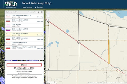
No one likes to be inconvenienced by road projects on their daily commute. Thanks to new mapping software, which debuted last week, residents have a new resource to keep them informed of county road projects and associated detours.
The Road Advisory Map is an interactive portal showing current road closures and restrictions — an open road with work being performed on it. The map also shows detour routes for road closures when one has been identified, a short description of the work being performed and the anticipated completion date.
Both the Weld County Department of Public Works and the county’s Geographic Information Systems (GIS) division saw a new map as a way to better inform the traveling public of not only the work being done on county roads but how to avoid a project completely by highlighting the detours.
“We’re always looking for ways to better inform our residents of the work we’re doing and how they may be impacted,” said Curtis Hall, Weld County Public Works Director. “In response to the calls we receive in Public Works and the wet weather we’ve had this year, which has required us to close roads quickly, we wanted to see if there was a way to provide a map that could be updated more quickly and be more user friendly.”
The user-friendly characteristics of the map include the advisories being color-coded (red for closures, pink for restrictions and green for detours.) Additionally, a side panel identifying all advisories eliminates the need to scroll the map for information. The map is also designed to easily function on different screen sizes.
“Specifically, we were able to create a user interface that functions well on a computer or mobile device,” said Sam Gould, Weld County GIS Supervisor. “This should create a better experience for the user no matter where they are or what device they're using.”
The Road Advisory Map replaces the Public Infrastructure Map, which was created following the 2013 flood to show residents and first responders what roads were impacted. Although the new map currently only shows information related to road projects, Jake Mundt, Director of Application and Database Systems for the Weld County Department of Information Technology, believes the functionality of the map and new technology will allow it and GIS as a whole to be even more of an asset in future emergencies.
“What we want to do with this new map is to reconcile and modernize the data, so that is more accessible to our citizens, and more easily maintainable by Public Works. We’re using better technology that makes it easier for everyone,” he said. “At the same time, GIS is focused on using technology to meet demand in emergency situations much more quickly and easily.”
View the Road Advisory Map.